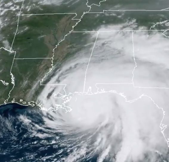
Hurricane Sally churned towards the US Gulf Coast on Tuesday, threatening deadly flash flooding in Alabama and Mississippi, even as it weakened to a Category 1 storm.
The National Hurricane Center said the storm could make landfall late Tuesday and was packing maximum sustained winds of around 80 miles (130 kilometers) per hour, a slight weakening from earlier in the day.
“Historic flooding is possible from Sally with extreme life-threatening flash flooding likely through Wednesday,” the Miami-based center warned, adding the storm could dump up to 20 inches (50 centimetres) of rain in some areas.
At 2100 GMT, Sally was about 85 miles south of Mobile, Alabama, and heading north at a crawling pace of two miles per hour in the Gulf of Mexico.
Sally is one of five tropical cyclones in the Atlantic Ocean — a phenomenon only recorded once before, in September 1971, according to meteorologists.
Alabama governor Kay Ivey warned state residents that even though the storm had weakened, “Hurricane Sally is not to be taken for granted.”
“We are looking at record flooding, perhaps breaking historic levels. And with rising water comes a greater risk for loss of property and life,” she told a press conference.
“I urge you in the strongest way possible to evacuate if conditions permit and seek shelter elsewhere as possible today.”
Ivey had declared a state of emergency Monday ahead of Sally’s arrival.
President Donald Trump, speaking on “Fox & Friends,” compared Sally to Hurricane Laura, which battered Texas and Louisiana, as well as the Caribbean, just a few weeks ago.
“This one is smaller but it’s a little bit more direct, but we have it under control,” he said. “We have it under watch very strongly.”
Earlier, he tweeted: “We are fully engaged with State & Local Leaders to assist the great people of Alabama, Louisiana, and Mississippi.”
He urged people in the storm’s path to “listen to State and Local Leaders.”
Mississippi Governor Tate Reeves had also declared a state of emergency ahead of the approaching storm.
He said the storm surge projections were “worrisome with anywhere from five to eight feet of coastal surge.”
Governor John Bel Edwards of Louisiana, which is still recovering after Hurricane Laura made landfall in the state as a Category 4 storm, told residents Monday to be prepared.
“Be smart and be safe,” he tweeted.
But the NHC predicted that Sally would make a northward turn away from southeastern Louisiana, to make landfall along the southern coast of neighboring Mississippi and Alabama.
There have been so many tropical storms in the Atlantic this year that the UN’s World Meteorological Organization, which names them, is about to run out of names for only the second time in history.
The last time was in 2005, the year Hurricane Katrina devastated New Orleans.
The latest Atlantic storm, Hurricane Paulette, pounded the island of Bermuda on Monday with Category 2 winds and heavy rains, according to the NHC.
The center also said Tropical Storm Teddy was expected to become a hurricane.


