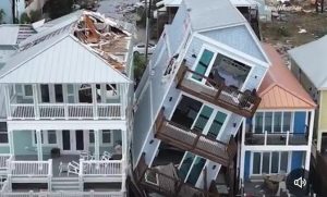
Tropical storm
Ian, the ninth tropical storm of the 2022 Atlantic hurricane season, has formed
around the central Caribbean Sea. The storm is expected to turn into a
hurricane before it hits Florida next week. Florida Governor Ron DeSantis has
already announced a state of emergency. If Ian hits, this will be the first
hurricane in Florida in four years.
Tropical
storm Ian: Path
Ian,
currently a tropical storm, is located nearly 270 miles south-southeast of
Kingston, Jamaica. The United States’ National Hurricane Center has observed a
strengthening of the forecast over the next few days. Forecast shows the
hurricane with gather in strength and first reach Cuba after where it will take
a brief pause and then hit Florida. The Gulf of Florida, including the eastern
Panhandle is at risk. Landfall is expected near Pensacola.
“The
Florida Division of Emergency Management, working together with the National
Hurricane Center to evaluate weather predictions, has determined there is a
continuing risk of a dangerous storm surge, heavy rainfall, flash flooding,
hazardous seas and isolated tornadic activity for Florida’s Peninsula and
portions of the Florida Big Bend, North Florida and North East Florida,”
DeSantis said.
Also Read | Tropical storm Fiona: All you need to know
“Ian is
likely to be near major hurricane intensity when it approaches western Cuba,”
the National Hurricane Center said, adding, “Since Ian is not expected to
remain over Cuba long, little weakening is expected due to the land
interaction.”
Tropical
storm Ian: Name
Tropical storm
Ian was initially called Tropical Depression Nine. It was named on Friday
evening. The name Ian has been used for a total of eight tropical cyclones
worldwide.
What is
a tropical storm?
A tropical depression,
storm and hurricane are three shades of the same thing. An organised system of
clouds and thunderstorms circle around a low-pressure area developing in warm
tropical waters. The categorisation of depression, storm and hurricane depends
of how intense the winds are and the way the weather processes are aligned.


