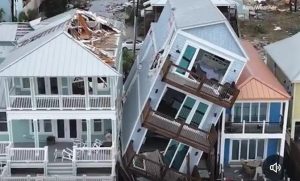
In the early hours of Wednesday morning, just hours before it was anticipated to make landfall over Florida‘s Gulf Coast, Hurricane Ian grew stronger and became a dangerous Category 4 hurricane.
Despite the possibility of modification in the hurricane’s path, timing, and intensity, a landfall is anticipated in the region around Port Charlotte and Sarasota. The state of emergency has been issued by Florida Governor Ron DeSantis.
Also Read| Hurricane Ian: Joe Biden says US administration is on alert
What does a cyclone 5 category mean?
Winds of 157 mph or higher are typical of a Category 5 hurricane. Even indoors, flying debris can endanger humans, livestock, and pets. The majority of mobile homes will be completely destroyed, as will a large proportion of frame homes. Commercial buildings with wood roofs will sustain significant damage, metal buildings may collapse, and nearly all high-rise windows will be blown out.
Most trees will be uprooted and power poles will be destroyed by a Category 5 hurricane. And, as with Category 4 hurricanes, power outages are expected to last weeks to months. People should prepare for long-term water scarcity.
Also Read| How to prepare for hurricanes and recover from them
Since 1924, only three Category 5 hurricanes have made landfall. Hurricane Andrew, which struck Florida in 1992 and is one of the most well-known hurricanes in recent memory, was a Category 5 hurricane. When it made landfall in 1969, Hurricane Camille was a Category 5, just like Hurricane “Labor Day” in 1935.
On September 19, the US National Hurricane Center identified Ian as a tropical wave to the east of the Windward Islands. On September 22, the wave moved into the Caribbean Islands, causing heavy rains in Trinidad and Tobago as well as the islands of Aruba, Bonaire, and Curacao. Throughout, the wave began to organise as wind speeds increased, which forecasters attribute to winds flowing out of Hurricane Fiona.
Also Read| What is the Atlantic hurricane season?
When it was named Tropical Depression Nine early on September 23, warm winds started to strengthen shortly after and persisted throughout the day and into the next morning. The warm wind-induced depression got better during the course of the day, and the NHC named the storm Hurricane Ian.


