
The coastal towns of Honduras and Nicaragua are under danger
of being hit by another powerful tropical storm, Iota, which would be the
second such storm to hit the region in less than two weeks.
Eta, a powerful tropical storm, hit the region in Central
America two weeks back killing more than 200 people.
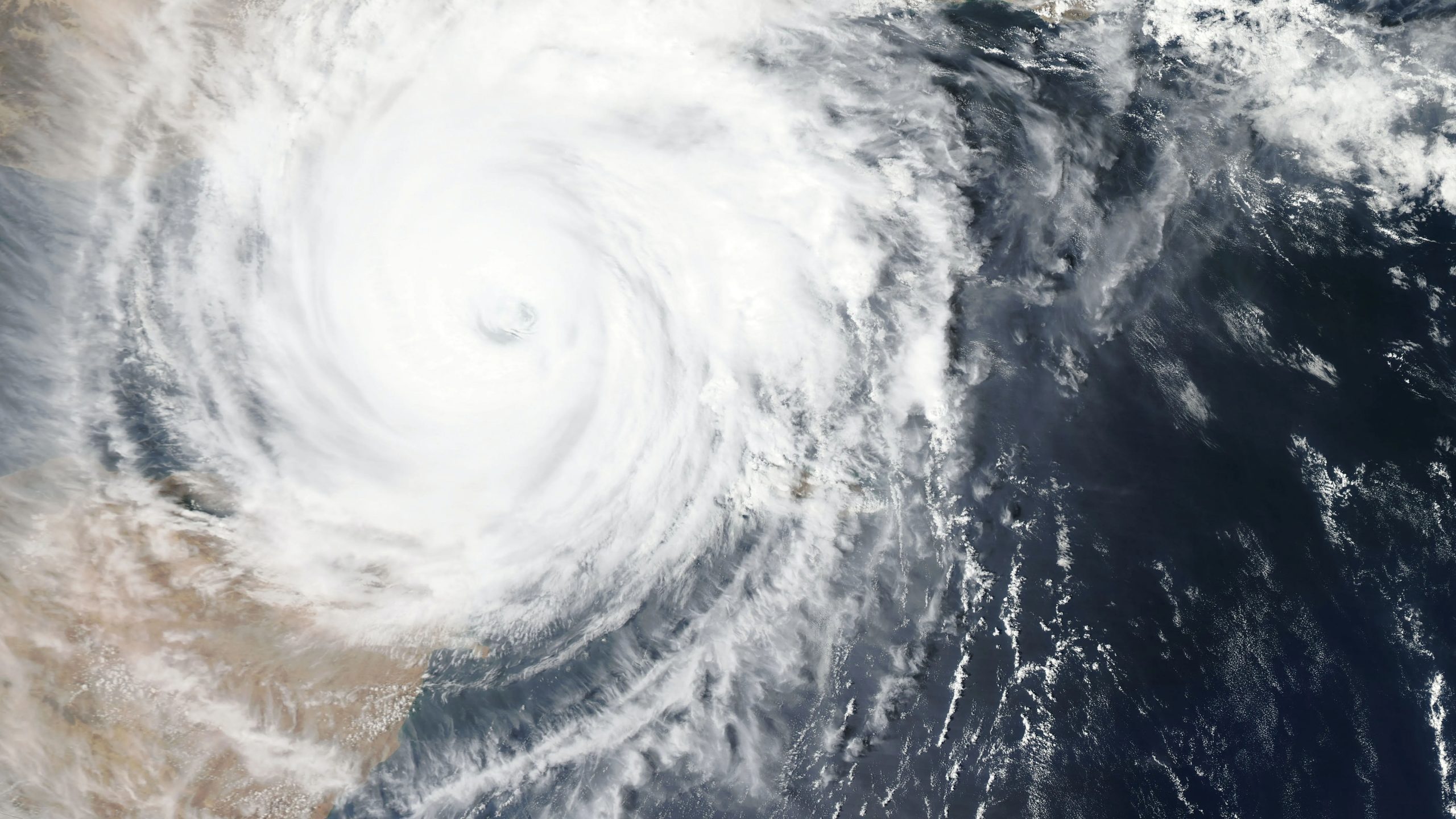
Iota, now expected to take the form of a major hurricane, is
moving towards the coasts of Honduras and Nicaragua with a maximum sustained
speed of about 50 (85 kmph).
“As of 1800 GMT, the storm was about 375 miles (600 kilometers) south of
Kingston, Jamaica, moving slowly to the west-southwest with maximum sustained
winds of 50 miles per hour (85 kph).
“It is projected to hit the Colombian island of Providencia
by late Sunday, likely with tropical storm force before gaining strength,” AFP
reported.
The National Hurricane Center (NHC) has upgraded the category
of the storm to “almost a hurricane”, and consequently, Honduras and Nicaragua
have also upped their category of threat from “Hurricane Watch” to “Hurricane Warning”.
It will “approach the coasts of Nicaragua and
northeastern Honduras on Monday… at or near major hurricane strength,”
the Miami-based agency said Saturday.
Honduras, Guatemala and Nicaragua announced evacuations
Friday, even as the region was still reeling from the devastation inflicted by
Eta.
Eta’s heavy rains burst river banks and triggered landslides
as far north as Chiapas, Mexico.
The NHC warned that Iota would deposit as much as 16 inches
(40 centimeters) of rain on Honduras, northern Nicaragua, eastern Guatemala and
southern Belize, with isolated totals of up to 30 inches.
That could lead to “significant, life-threatening flash
flooding and river flooding, along with mudslides,” the NHC said.
“Through Thursday, heavy rainfall from Iota will likely lead
to life-threatening flash-flooding and river flooding across portions of
Central America. Flooding and mudslides in Honduras Nicaragua could be
exacerbated by Hurricane Eta’s recent effects there…,” it said.
The agency also warned of a surge in sea level by at least 9 feet, accompanied by strong waves.
“A dangerous storm surge will raise water levels by as much
as 9 to 13 feet above normal tide levels in areas of onshore winds along the
coast of Nicaragua and Honduras. Near
the coast, the surge will be accompanied by large and destructive waves,” it
said.
Authorities in Honduras on Friday ordered police and the
army to evacuate the area of San Pedro Sula — the country’s second city and
industrial capital, located 110 miles north of Tegucigalpa.
Eta hit that area hard: About 40,000 people are still in
shelters across the country.
The government also ordered water released from Honduras’s
main hydroelectric dam, due to danger of it overflowing from Iota’s rains.
In Nicaragua, authorities were preparing for “floods,
rain, high tides, wind and landslides on saturated soil,” said Guillermo
Gonzalez, head of the country’s disaster response agency Sinapred.
Initial estimates show “some 80,000 families are going
to be at risk,” he said, with evacuations underway in communities along
the border with Honduras.
Authorities on Friday sent boats to evacuate the community
in Cabo Gracias a Dios, where the Coco River flows into the Caribbean along the
“Mosquito Coast.”
Guatemala’s disaster management agency CONRED meanwhile
called on residents in the north and northeast to voluntarily evacuate.
Eta hit the Caribbean coast of Nicaragua as a Category 4
storm, one of the strongest November storms ever recorded.
Warmer seas caused by climate change are making hurricanes
stronger for longer after landfall, scientists say.
This year’s hurricane season has seen a record 30 named
tropical storms across the Caribbean, Central America and the southeastern US.


