
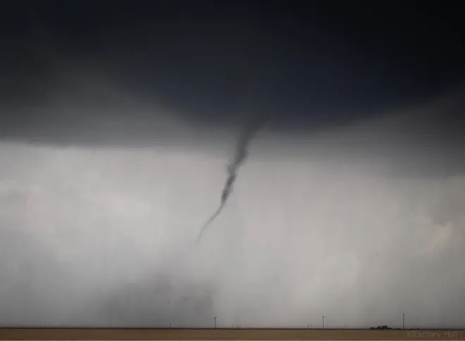
As a violent storm with strong winds moved out of the Texas panhandle Sunday evening, tornado sightings were recorded in Oklahoma and Kansas.
As of early Monday morning, Oklahoma still had tornado watches and warnings in place. According to FOX Weather, at least two tornadoes were seen in Oklahoma City, and Norman and Shawnee had damage. In southwest Oklahoma, numerous reports of gusts between 70 and 90 miles per hour were made.
Also Read| What is ‘derecho’? Meaning, pronunciation of the weather term as storms approach central, eastern US
In the Kansas city of Liberal, a tornado damaged a house and brought down power lines and trees.
In Hall County, Texas, wind gusts of 114 miles per hour were also noted. One individual was hurt in El Paso County’s Fort Bliss after being blown off their feet by other gusts that reached 70 mph in Amarillo and El Paso. El Paso experienced the seventh-strongest gust in the city, with winds gusting at 71 miles per hour.
Leaning power lines in Fort Bliss forced the closure of an exit from Interstate 10.
Also Read| Who was Betty Boothroyd, first woman Speaker of the House of Commons in the UK?
Forecasters issued a warning that blowing dust could restrict visibility in the Oklahoma City metropolitan region to just two miles. Residents of McLean, Texas, were advised to seek shelter from a potential tornado Sunday night.
Storms might develop into derecho status, which is a wind storm with a line of swiftly moving thunderstorms that extends hundreds of miles.
Some thunderstorms have been observed travelling at speeds of up to 100 mph with gusts of 90 mph. In Oklahoma, numerous advisories, watches, and warnings for severe weather were issued.
Meteorologists recommended affected residents to secure loose things, drive slowly, and get ready for strong winds. As strong, destructive tornadoes with theoretical wind speeds greater than 200 mph, tornadoes might potentially achieve the F3 rating.
Also Read| The Mandalorian season 3: What to expect from Moff Gideon’s return?
Some locations, including Norman, Oklahoma, had isolated huge hail up to the size of a baseball.
The severe weather danger, which ranges from parts of Texas to Missouri, affects more than 10 million people. There is a chance that tornadoes will form over sections of north Texas, western Oklahoma, and parts of Kansas and Missouri.
Through early Monday morning, blowing dust advisories and high wind warnings were issued for large portions of New Mexico, Texas, and Oklahoma. Throughout the day, the warnings are anticipated to move to the east and enter the Ohio and Mississippi Valleys.
Also Read| Which two The Mandalorian episodes are all-time fan favourites and why
The area under threat from severe storms on Monday includes parts of Indiana, Ohio, and Tennessee, with eastern Kentucky, southern Indiana, and Ohio anticipated to have the highest risk.
As the storm system moves away from the Eastern Seaboard on Tuesday, the risk of catastrophic weather will decrease.


