
Tropical Storm Idalia is slated to become a Category 3 hurricane as it approaches the coast of Florida, expected to bring along with it heavy rains, high winds and damaging storm surge.
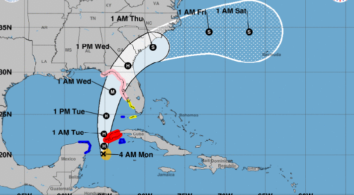
The tropical storm is strengthening quickly and is expected to intensify into a hurricane on Monday. It is expected to make landfall near the Big Bend of Florida on Wednesday morning, according to the National Hurricane Center. The hurricane center said early Monday that as Idalia intensifies, “life-threatening storm surge and dangerous winds” will become “increasingly likely for portions of Florida.”
Also Read | After earthquake, Hurricane Hilary, ‘locusts’ is next for California, joke social media users
The state of Florida has deployed swift water rescue teams and local officials have called for evacuations, as well as school closures. Residents have been warned to prepare for the impending natural disaster.
At present, the storm is located about 90 miles off the western tip of Cuba, with the wind speed reaching 65 mph, the hurricane center said.
“Idalia has been moving erratically and is nearly stationary,” the hurricane center added in a 8 a.m. ET update. “A motion toward the north-northeast and north is expected to begin later today, bringing the center of Idalia over the extreme southeastern Gulf of Mexico by tonight.”
Also Read | Seals gather along Monterey coast of California ahead of Hurricane Hilary | Watch video
A hurricane watch has been issued from Englewood to India Pass, along Florida’s Gulf Coast, including Tampa Bay, according to the hurricane center. A tropical storm warning is also in place for the Dry Tortugas, Florida. In addition, a tropical storm watch has been issued for the Lower Florida Keys west of the west end of the Seven Mile Bridge.
“It should be emphasized that only a small deviation in the track could cause a big change in Idalia’s landfall location in Florida due to the paralleling track to the west coast of the state,” the hurricane center noted.


