
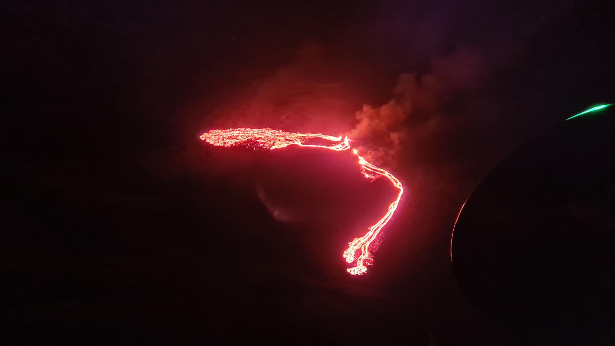
A volcano erupted just 40 km (25 miles) from Iceland’s capital Reykjavik on Friday, a red cloud lighting up the night sky as a no-fly zone was established in the area.
“Volcanic eruption has begun in Fagradalsfjall. Flight colour code is red but very little turbulence is seen on seismometers,” Iceland’s Meteorological Office, which monitors seismic activity, wrote on Twitter.
Police and coast guard officials raced to the scene late Friday, but the public has been advised to stay away from the area.
Also Read: Continuous tremors rock Iceland as geologists fear possible volcanic eruption
The Krysuvik volcanic system, which does not have a central volcano, is located south of Mount Fagradalsfjall on the Reykjanes peninsula in southwestern Iceland.
“The first notification was received by the Meteorological Office at 9.40 GMT. The eruption was confirmed through webcams and satellite images,” the institute said on its website.
While Iceland’s Keflavik International Airport and the small fishing port of Grindavik are only just a few kilometres away, the area is uninhabited and the eruption was not expected to present any danger.
Also Read: Floods and volcanic ashfall affect thousands in Ecuador
Volcanic eruptions in the region are known as effusive eruptions, where lava flows steadily out of the ground, as opposed to explosive ones which spew ash clouds high into the sky.
The Krysuvik volcanic system has been inactive for the past 900 years, according to the Meteorological Office, while the last eruption on the Reykjanes peninsula dates back almost 800 years, to 1240.
But the region has been under increased surveillance for several weeks after a 5.7-magnitude earthquake was registered on February 24 near Mount Keilir on the outskirts of Reykjavik.
That quake has since been followed by an unusual number of smaller tremors — more than 50,000, the highest number since digital recordings began in 1991.
The seismic activity has since moved several kilometres southwest, concentrating around Mount Fagradalsfjall, where magma was detected just one kilometre under the Earth’s surface in recent days.
Iceland has 32 volcanic systems currently considered active, the highest number in Europe. The country has had an eruption every five years on average.
The vast island near the Arctic Circle straddles the Mid-Atlantic Ridge, a crack on the ocean floor separating the Eurasian and North American tectonic plates.
The shifting of these plates is in part responsible for Iceland’s intense volcanic activity.
The most recent eruption was at Holuhraun, beginning in August 2014 and ending in February 2015, in the Bardarbunga volcanic system in an uninhabited area in the centre of the island.
That eruption did not cause any major disruptions outside the immediate vicinity.
But in 2010, an eruption at the Eyjafjallajokull volcano sent huge clouds of smoke and ash into the atmosphere, disrupting air traffic for more than a week with the cancellation of more than 100,000 flights worldwide and leaving some 10 million passengers stranded.


