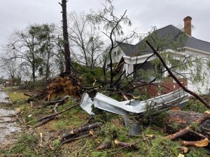
As many as half a dozen tornado warnings have been issued in different regions of central and northern New Jersey as strong thunderstorms are lashing parts of the state.
According to the National Weather Service, at least one twister, which it described as “a large and dangerous tornado,” was confirmed on the ground in parts of Mercer and Hunterdon counties shortly before 6 pm.
At least 6 tornado warnings have been issued in parts of the state that include Quakertown, Hunterdon County, northwestern Mercer County, Monmouth, Ocean county, Bucks and Philadelphia county.
Atlantic, Burlington, Camden, Cape May, Cumberland, Gloucester, Hunterdon, Mercer, Middlesex, Monmouth, Morris, Ocean, Salem, Somerset, Sussex, and Warren counties will all be under a tornado watch until 9 pm on Thursday.
ALSO READ | Fast-moving tornadoes cause severe damage in Iowa
According to the forecast by the NWS, rain and thunderstorms are expected to develop in the region throughout the afternoon and evening on Thursday. The forecast says that the storms will bring heavy rain, hailstorm, and potentially damaging winds across the region. The forecast also predicts a possibility of an isolated tornado.
The time between 4 pm and 9 pm on Thursday has been earmarked as the time when there is a great possibility of severe storms across the region. Wind gusts could cause trees to fall and cause power outages, along with chances of isolated flash flooding. Drivers in the region have been advised to avoid flooded roads and to never drive through standing water.
ALSO READ | Climate mysteries still puzzle scientists, despite progress
Many storms have hit the New Jersey area in the past but due to its location, not many have hit the state directly. Nine storms have caused a rainfall of 10 inches (250 mm) in the state, including a hurricane in 1940 that interacted with a cold front and caused a rainfall of 24 inches (610 mm) in the city of Ewan. Many hurricanes that remained offshore and did not hit the state directly, have each drowned small numbers of swimmers.


